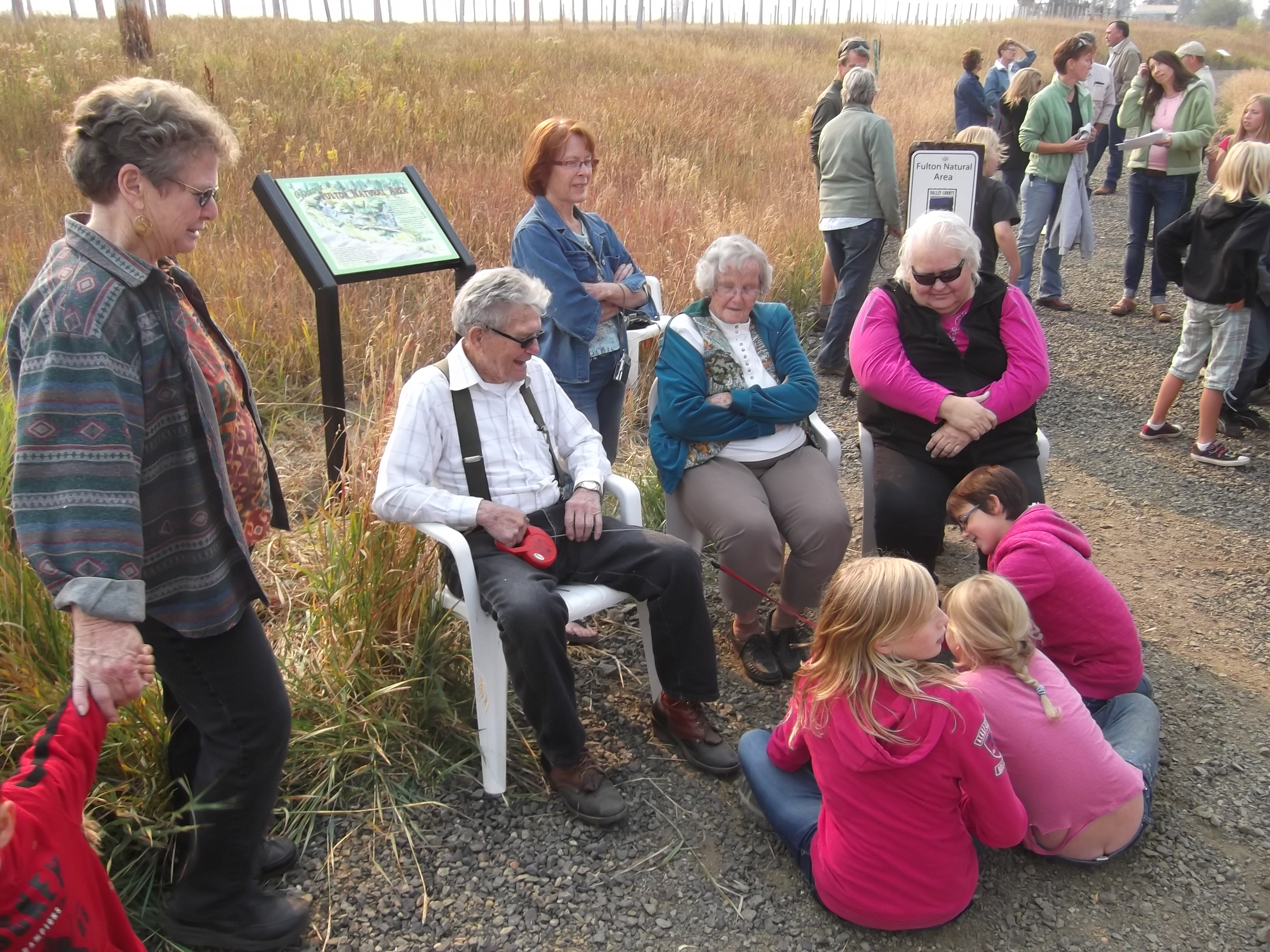
Dedication of the Boulder Creek Trail in the Fulton Natural Area … definitely one of our highlights over the last 10 years!
Hi all,
I think it’s fair to say that the new Master Plan for Valley County Pathways was a hit with the Valley County Planning & Zoning Commission in March. The commissioners voted unanimously to move it forward to the Valley County Commission for adoption in May.
“I’d really like to thank the Pathways group for putting this plan together,” said Ed Allen, a McCall-based member of Valley County P&Z. “It’s not every day that we have a group that brings us a plan like this. It’s really quite comprehensive. It will be an important tool that can be used for the future planning and development of pathways in our valley.”
“I think it’s really awesome,” added P&Z Commissioner Johanna Defoort.
The Star News in McCall covered the story, printed on the front page of the March 16 issue.
If adopted by the Valley County Commission, the newly updated 37-page Master Plan would be incorporated into the Valley County Comprehensive Plan, a document that guides the future planning and development of the county. The previous Master Plan was adopted by Valley County government in 2005. The plan also is strengthened by the latest pathway plans developed by the Cities of McCall, Donnelly and Cascade, and it also embraces the North Fork Payette River online Water Trails recreation guide. A new 2-inch binder contains all of the plans in living color, including all the maps.
“I think the plan is going to be an excellent document for the county and the cities to use moving forward,” said Steve Stuebner, vice president of the VCP board of directors, who presented the new Master Plan to the P&Z Commission.
The plan’s vision has stood the test of time, Stuebner said. The Vision Statement of VCP is as follows:
 Vision Statement
A north-south pathway system in Long Valley would seek to connect the communities of McCall, Donnelly, Lake Fork and Cascade, complete a pathway around Payette Lake, and establish a pathway corridor around Lake Cascade. To the maximum extent possible, the Valley County Pathway System would connect valley trails to community and neighborhood pathway networks, tourism amenities and services, parks, schools, natural areas, and national forest roads and trails.
In our update, the vision now includes linking to Adams County, New Meadows and the Weiser River Trail.
Stuebner pointed out a long list of accomplishments that have occurred since 2005 by VCP and partner organizations, including:
- Creation of VCP web site, brochures, T-shirts and bonafide non-profit 501 (c) 3 organization. Valleycountypathways.org
- Extension of the Crown Point Trail by ¼ mile in each direction through a donation of real property from the Putman Family to Valley County Pathways in 2006.
- Creation of the North Valley Trail from River Ranch to Heinrich Lane via property donations and easements. The trail opened in 2007 and new pieces have been added since that time.
- Acquisition of multiple easements on the old Railroad Right of Way from the Idaho Power Company from McCall to Donnelly.
- Creation of the Strand in Cascade, a 2-mile trail that runs along the North Fork of the Payette River from the south bridge to the Water’s Edge RV park. The trail also ties into pathways and observation decks at Kelly’s Whitewater Park on the North Fork Payette River, and it parallels The Strand Water Trail. Special thanks go to Dwight Jividen for development of The Strand and to the Marc Pickard family for the beautiful pathways, green space and observation areas next to the whitewater park.
- Creation of the Boulder Creek Trail in Donnelly through the donation of property by Hugh and Georgia Ann Fulton and a substantial grant from the Boise National Forest Resource Advisory Council (RAC). The trail opened in 2012.
- Linking up groomed cross-country ski trails from the Activity Barn to the North Valley Trail for xc skiing, snowshoeing and fat biking, working with Brundage Mountain Resort. The new xc trails at the Activity Barn are a substantial improvement to the overall mileage and diversity of the winter trail system.
- Improved highway signage pointing out pathway trailheads to motorists and tourists visiting the valley.
- Creating a new Master Plan and Master Plan map, outlining existing and proposed pathway corridors along with xc ski trails, water trails and key public trailheads in Valley County and Adams County.
- Working to expand space for bike lanes on Warren Wagon Road when the Federal Highways Administration plans to repave a 5.5-mile section of the road in 2018.
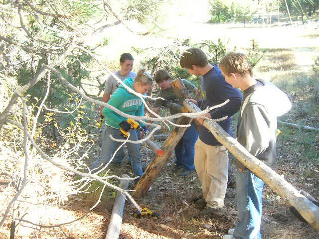
Cascade High School kids build buck fence along the Crown Point Trail as part of a class project
Milestones accomplished by our partner organizations:
- Substantial update of the McCall Area Pathways Master Plan in 2012.
- Creation of the Donnelly Pathways Master Plan in 2014 with an emphasis on creating pathway corridors that tie together between Donnelly and Lake Cascade.
- Creation of the Cascade Bike and Pedestrian Plan in 2015.
- Development of a new, detached pedestrian pathway from the City of McCall to Bear Basin Road (summer use only at this time).
- Creation of the Payette River Water Trails online story board and detailed guide to 10 water trails in the North Fork Payette River Basin. This product turned out extremely well. See more at http://wcmedc.org/recreation/.
- Creation of a new detached pedestrian pathway along Deinhard Lane between the Ridley’s Shopping Center and Spring Mountain Drive.
- Creation of a new detached pedestrian pathway from River Ranch to Lick Creek Road, and then along Lick Creek Road to Shady Lane.
We will post the executive summary of our new Master Plan and full text of the plan on this web site.
I’d like to hit on a few more high points in our plan.
Highest priority projects for VCP:
- Work on property easements or donations of property along the old Railroad ROW from Lake Fork to Pine Lakes Ranch. In particular, VCP is focusing on working with property owners along the RR ROW between Lake Fork and the city of Donnelly, starting from the south and north ends and moving toward the middle.
- In the interim, develop “Share the Road” or “Bike Route” on Norwood Lane from Lake Fork Road to West Roseberry Road in Donnelly, providing a public road corridor for bicyclists, walkers and trail-runners, tying together the communities of Lake Fork and Donnelly.
- Develop public road corridor connecting Valley County to Adams County and the Weiser River Trail. We have identified the Fish Lake Road and Big Creek Road as the public roads connecting a public corridor between the two counties. These corridors should be signed with “Share the Road” or “Bike Route” signage to show people the way to connect to Adams County and the Weiser River Trail.
- Work on developing a detached pathway or bike lanes from Roseberry Road to Roseberry (aligns with City of Donnelly priority) and on Farm to Market Road from Roseberry to Elo Road, Krahn Lane and Sampson Trail to link Farm to Market to McCall (aligns with city of McCall priority).
- Work on developing a detached pathway on West Mountain Road from Blackhawk to Tamarack Falls.
- Work on developing a detached pathway on West Deinhard Lane to the junction with the existing McCall bike path near Mission Street.
- Continue working on pathway corridor around Payette Lake. New, wider bike lanes will be built on Warren Wagon Road on the west side of the lake in 2018. In the meantime, we recommend applying for grant funds to commission a study of building a detached pathway around the east side of Payette Lake. A study will help understand the different land ownerships and costs involved.
- Work toward more detached bike paths along Lick Creek Road from Shady Lane to East Side Drive. This initiative connects to the goal of building a pathway around Payette Lake.
- Work toward building bike lanes or a detached pathway along Davis Road to Gold Fork Hot Springs, a popular destination.
- Work with the Bureau of Reclamation and the Idaho Department of Parks and Recreation to develop pathway corridors around Lake Cascade. A system of priorities should be developed for these potential pathway segments to determine which ones should be focused on in the near term vs. long term.
- Develop detached pathways between the city of Donnelly and Tamarack Falls on West Roseberry Road. The City of Donnelly is working on developing a detached pathway on the south side of West Roseberry Road to Dawn Drive and the city beach as a high-priority.
- Develop a detached pathway along Cabarton Road from the Clear Creek junction to the city of Cascade.
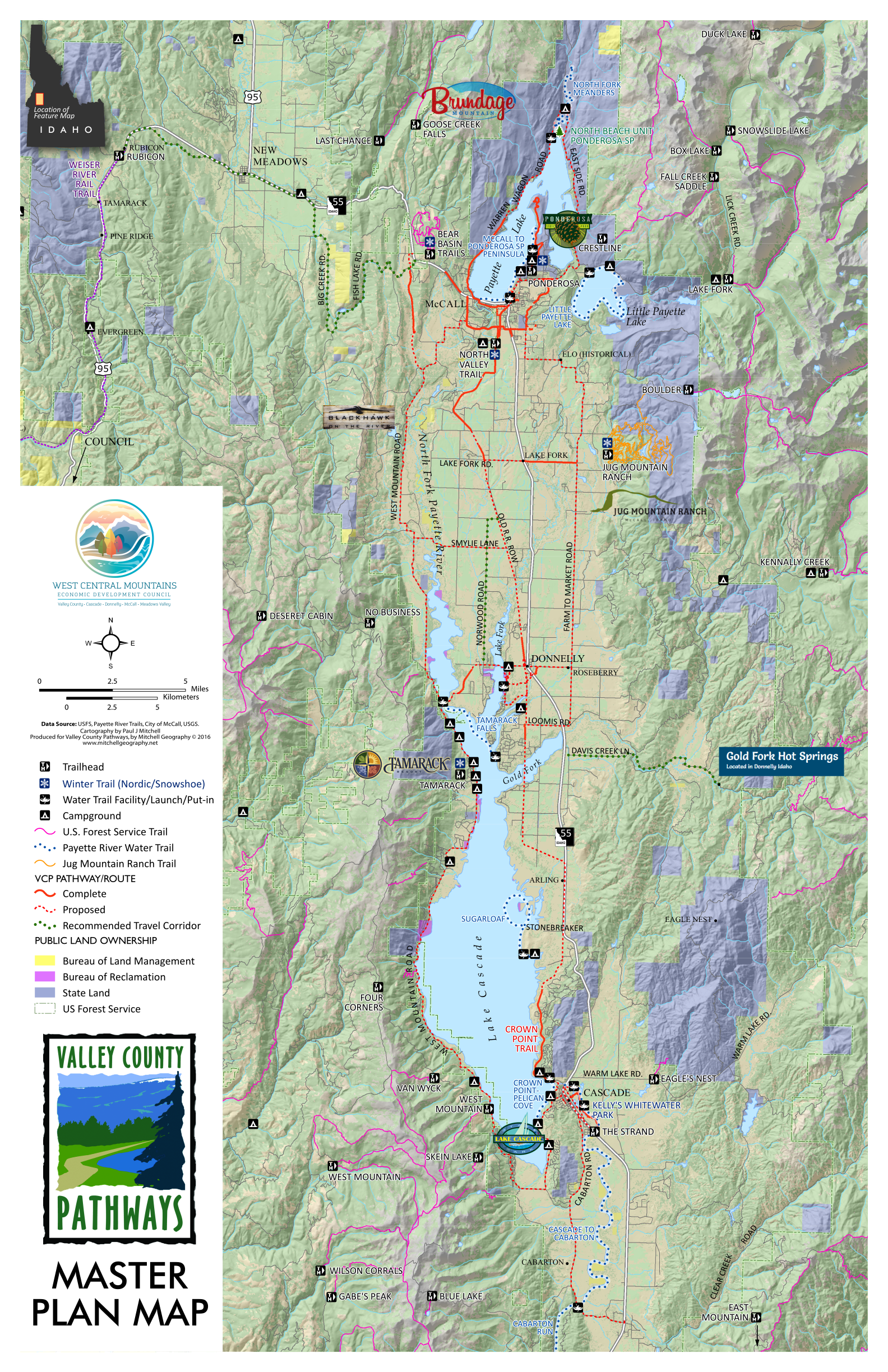
We love the new Master Plan map, shown above, created by Paul Mitchell of Mitchell Geography. It’s great to see how all of the pathways or pathway corridors link up to Forest Service trailheads, state parks, Jug Mountain Ranch, Tamarack Resort, Bear Basin and other points in the valley. The map also delineates the Water Trails. The map was built on a GIS platform. It will be shared with Valley County government so they can fit it into their overall data base and maps.
We want to thank everyone for their support in developing the new Master Plan. We received letters of support from the McCall Parks & Recreation Dept., Donnelly Pathways Member Brett Shepherd, Andrew Mentzer, executive director of the Valley County Economic Development Council, Cascade Lakes Realty and the America’s Best Communities organization in Valley and Adams county.
Please stay in touch and help us get over the final hurdle with the Valley County Commission in early May!
Contact Steve if you have any questions about the plan … Thanks!
Comments are closed